The Scotty Creek climate change research centre in the Northwest Territories, one of the first Indigenous-led research stations in the world that provided information on the climate crisis that was used around the world, has just burned down in a forest fire well outside the typical forest fire season, another sign of worsening climate crisis.
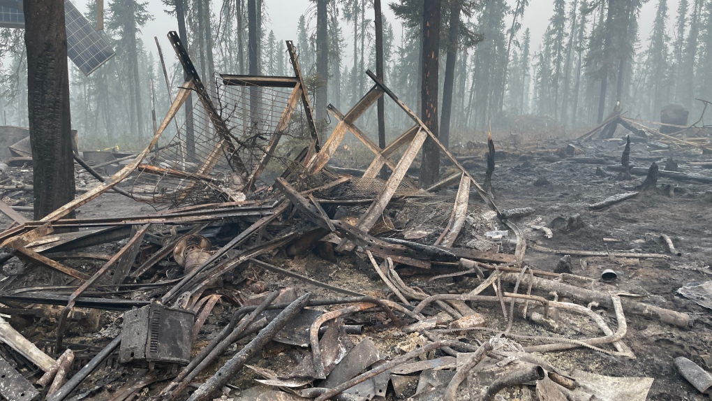
Damage caused by a wildfire at Scotty Creek Research Station, roughly 50 kilometres south of Fort Simpson, N.W.T. is shown in this undated handout photo. THE CANADIAN PRESS/HO, Scotty Creek Research Station
The Łı́ı́dlı̨ı̨ Kų́ę́ First Nation says the Northwest Territories' Scotty Creek research station has been "almost completely destroyed" by a forest fire. Located 50 kilometres south of Fort Simpson, Scotty Creek is one of the first Indigenous-led research stations in the world. It’s also one of the few long-term research stations in the North.
Organizations from around the world, including the IPCC, use data collected at the site to try to understand the progress of climate change in one of the most rapidly warming regions on Earth. The damage comes after a historic year in which Scotty Creek become a fully Indigenous-led research station, embracing a collaborative partnership with Wilfrid Laurier University. ... The First Nation, which has been collaborating with researchers since the 1990s, took over leadership of the station in August. ...
Scotty Creek has been in place since the 1990s. It also happens to be situated near the southern edge of permafrost, Scotty Creek director Bill Quinton told Cabin Radio last month, when the fire first threatened. (Quinton was not available for comment before publication of this latest report.)
Quinton said the station was put in at a time when a lot of environmental changes were noted due to climate warming. Over the past quarter of a century, researchers have collected an invaluable data archive, he said. ...
Data collected at Scotty Creek is shared globally. Researchers from at least six Canadian universities and institutions in the United States and Europe will be directly affected, The Łı́ı́dlı̨ı̨ Kų́ę́ First Nation reported.
In a press release, the First Nation reported that five of Scotty Creek’s nine buildings, which include facilities used as laboratory space, sleeping accommodations and the storage of research equipment, burned to the ground. The rest of the buildings have been damaged to varying extents, the First Nation stated, and some will need to be replaced. Many storage containers that housed scientific equipment and tools were reportedly destroyed, as were support structures, platforms and solar arrays. ...
This year's wildfire season has been the most severe the territory has seen since the extremes of 2014, with the total area burned surpassing the 10-year average and nearly tripling the five-year average. A total of 257 fires have blazed across the territory this year, 30 of which are still active, burning a total of roughly 6,866 square kilometres.
https://www.pentictonherald.ca/spare_news/article_f969ef9a-9d07-5498-bd6...

